
Coastal tour: Grosseto-Monte Argentario
Content
The southernmost section of the Tuscan coast stretches from Grosseto, past Marina di Grosseto, through the Maremma Natural Park and Talamone, to the Orbetello Lagoon and up Monte Argentario. Here the coast is at its wildest: natural beaches, pine forests, lagoons with flamingos, and finally a mountainous promontory with two port towns. Here you will find the stages of the route, beaches, and market days.
The route at a glance
- Route: Grosseto – Marina di Grosseto – Alberese (Maremma Natural Park) – Talamone – Orbetello – Monte Argentario (Porto Santo Stefano, Porto Ercole), around 70 km
- Blue Flags 2026: Marina di Grosseto, Orbetello and, for the first time, Monte Argentario
- Markets: Grosseto Thu, Orbetello Sa, Porto Santo Stefano Di, Porto Ercole Mon
- Islands: Ferries to Giglio and Giannutri from Porto Santo Stefano
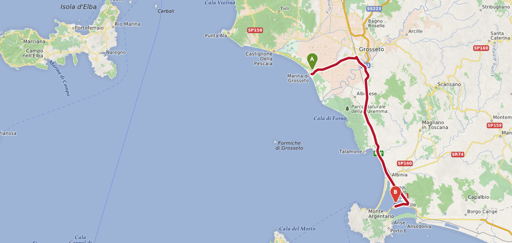 Data from OpenStreetMap - Posted under ODbL
Grosseto, Marina di Grosseto and the Maremma Natural Park
Marina di Grosseto and Principina a Mare
The provincial capital Grosseto ( Grosseto city tour ) has its own seaside resort, Marina di Grosseto, located about 10 km west of the city. The wide sandy beach, set back from a pine forest, stretches north to Castiglione della Pescaia and south past Principina a Mare to the mouth of the Ombrone River. Marina di Grosseto will be awarded the Blue Flag in 2026. A weekly market is held in Grosseto on Thursday mornings.
Maremma Natural Park near Alberese
South of the Ombrone estuary begins the Maremma Regional Park, with approximately 25 km of undeveloped coastline. Only the beach at Marina di Alberese is accessible by car; the coves in the park's interior, such as Cala di Forno, can only be reached on foot or by bicycle, sometimes requiring a guided tour in the summer. Further details can be found under " Quiet beaches of Tuscany" and "Sandy beaches of the Maremma".
Talamone and the Orbetello Lagoon
Talamone
Talamone lies on a small promontory west of the SS1 Aurelia (Fonteblanda exit) on the southern edge of the nature park. This fishing village, with its castle and small marina, has always been strategically important due to its location; in 1860, Garibaldi's ships stopped here on their way to Sicily. Watchtowers along the coast are reminders of the time spent defending against pirates.
Orbetello
Orbetello lies in the middle of the lagoon on a narrow peninsula and is connected to Monte Argentario by a causeway. The town dates back to an Etruscan settlement; from the mid-16th century, it was the capital of the Spanish "Stato dei Presidi." Fortifications and the old windmill in the lagoon date from this period. The Cathedral of Santa Maria Assunta is also worth seeing. The lagoon is an important bird sanctuary (WWF oasis) where flamingos are often spotted. Two spits close it off from the sea: Giannella to the north and the car-free Feniglia to the south with its long sandy beach. Orbetello received the Blue Flag award in 2026; the weekly market is held on Saturday mornings.
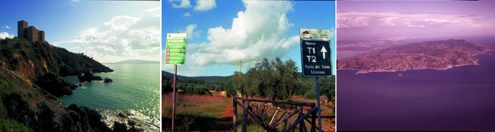
Left picture: Watchtower at Talamone. Middle picture: Hiking near Talamone. Right picture: Monte Argentario peninsula. All images with the kind permission offotoseca ENIT.
Monte Argentario
The mountainous promontory (highest point Punta Telegrafo, 635 m) is connected to the mainland by the two sandbars and the Orbetello causeway. In 2026, the municipality of Monte Argentario received the Blue Flag award for the first time.
Porto Santo Stefano
The main town in the north is a lively port with a promenade and the Spanish fortress (Rocca Spagnola). Ferries from Toremar and Maregiglio depart daily from here to the island of Giglio (crossing time approximately one hour), and during the season also to Giannutri . Market day is Tuesday mornings.
Porto Ercole
To the south lies the smaller Porto Ercole with its fishing harbor, old town, and the Spanish fortresses Forte Filippo and Forte Stella. The painter Caravaggio died here in 1610. The market is held on Monday mornings. To the west lies Feniglia, and to the east, Ansedonia with the remains of the Roman city of Cosa.
Tour along the panoramic road
The Strada Panoramica winds around the mountain, offering magnificent views of Giglio and its bays. It is narrow, winding, sometimes very steep, and in sections unpaved; after heavy rain, it is occasionally closed (most recently in February 2025 near Cala Grande). It is not recommended for motorhomes or vehicles towing trailers. Beyond Capalbio, a good 20 km southeast of Orbetello, Lazio begins – this is where our coastal tour ends.
Weekly markets between Grosseto and Monte Argentario
| Location | Market day |
|---|---|
| Grosseto | Thursday |
| Orbetello | Saturday |
| Porto Santo Stefano | Tuesday |
| Porto Ercole | Monday |
| Castiglione della Pescaia | Saturday |
You can find all market days under Markets in Tuscany , and the beaches of the entire coast under Tuscany: Sea and Beach . Previous section: Coastal tour Scarlino – Grosseto.
Find accommodation at Monte Argentario
Frequently asked questions about the coast between Grosseto and Monte Argentario
When is the market in Orbetello?
The weekly market in Orbetello takes place on Saturday mornings.
When is the market in Porto Santo Stefano and Porto Ercole?
In Porto Santo Stefano on Tuesdays, in Porto Ercole on Mondays, both in the morning.
Which beaches on Monte Argentario and in Orbetello have been awarded the Blue Flag?
In 2026, Marina di Grosseto, Orbetello and for the first time Monte Argentario will wear the FEE Blue Flag.
How do I get to the island of Giglio?
Take the ferry from Porto Santo Stefano. Toremar and Maregiglio operate daily; the crossing takes about an hour.
Is it possible to drive around Monte Argentario?
Yes, via the Strada Panoramica. However, it is narrow, winding, and partly unpaved, and is occasionally closed after severe weather; it is not suitable for motorhomes.